YellowScan and Nokia announce strategic partnership to enable 5G based LiDAR scanning for industrial use cases

August 23rd, 2024, Montpellier and Espoo – YellowScan a leading provider of advanced Lidar technology, and Nokia, a B2B technology innovation leader, are pleased to announce a strategic partnership aimed at revolutionizing industrial operations through the integration of the YellowScan Surveyor Ultra Lidar scanner into the Nokia Drone Networks solution.
This collaboration focuses on automation of 5G based LiDAR scanning on drones for telecommunications tower and utilities inspections, mining use cases, where precision, efficiency, and safety are paramount. The joint development plans of both companies bear the potential to reduce the operational cost of industrial inspections in the selected verticals by more than 60%.
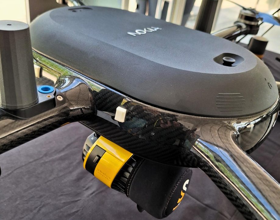
The deployment of YellowScan’s Surveyor Ultra as one of the key payloads for Nokia Drone Networks and leveraging 5G to stream the LiDAR scanning results in real-time are key elements to this partnership. The Nokia drone-in-a-box solution together with Yellowscan’s LiDAR scanners will significantly enhance the capabilities of Nokia drones, enabling automated, high-resolution scans and the creation of highly accurate digital twins of industrial sites.
Key Aspects of the Partnership:
- Advanced Lidar Integration: YellowScan’s Surveyor Ultra will be integrated into the Nokia Drone Networks solution, providing unparalleled accuracy and detail in 3D mapping and environmental scanning. This integration is essential for precise inspections and assessments in challenging industrial environments.
- 5G Native Connectivity: The 5G-native Nokia drone solution will ensure real-time data transmission, allowing instant analysis and decision-making. This high-speed connectivity is crucial for applications requiring immediate insights, such as detecting structural issues in telecom towers or when assessing operational safety for mining and utilities. 5G also enables remote operations, flying Beyond Visual Line of Sight (BVLOS) without personnel in the field.
- Automated Inspections and Scans: The collaboration will enable fully automated inspection routines, reducing the need for manual interventions and minimizing human exposure to hazardous environments. Automated scans will ensure consistent data quality and repeatability, improving overall operational efficiency.
- Creation of Digital Twins: Utilizing the high-fidelity data captured by YellowScan Surveyor Ultra, Nokia Drone Networks will facilitate the creation of digital twins within the Mission Critical Industrial Edge (MXIE) and enable virtual replicas of physical assets. These digital twins will allow for detailed analysis, predictive maintenance, and simulation, driving better asset management and operational planning.
- Enhanced Safety and Efficiency: By combining the robust Nokia drone technology with YellowScan’s precise sensing capabilities, the partnership aims to set new benchmarks for safety and efficiency in industrial inspections and operations. This collaboration will help industries transition towards more automated, data-driven processes, reducing costs and improving reliability.
“We are excited to collaborate with Nokia to bring our YellowScan Surveyor Ultra to new heights,” said Tristan Allouis, CEO at YellowScan. “Our sensors are designed to deliver the accuracy and reliability needed for critical industrial applications, and when paired with the 5G connected Nokia drone solution, we can truly transform how industries operate.”
“This partnership is a game changer. With our embedded 5G UAV technology, Yellowscan’s LiDAR scanners will be able to deliver real-time scanning directly to experts, making operations more efficient. When flying Beyond Visual Line of Sight using 4G/LTE or 5G connectivity, all data is streamed in real time over the network and collected at the edge cloud platform. No need for personnel on site or manually collect data from the SD (memory) cards”, said Thomas Eder, Head of Embedded Wireless at Nokia. “Our Nokia Drone Networks solution enables automation of the entire LiDAR scanning process, cutting costs and removing the need for repeated site visits. This advancement not only boosts our Nokia Drone Networks and Mission Critical Industrial Edge (MXIE) platform capabilities but also takes industrial automation to the next level.”
This partnership marks a significant step forward in the industrial application of drone technology, showcasing the potential of combining advanced sensing with cutting-edge 5G connectivity. Both companies are committed to continuing their collaboration to develop new solutions that address the evolving needs of industries worldwide.
The integrated solutions from this partnership will be showcased at the upcoming INTERGEO in Stuttgart 24 to 26 September, where attendees will have the opportunity to see live demonstrations and interact with the new technology.
About YellowScan
YellowScan designs, develops, and produces UAV LiDAR solutions for professional applications. Known for their accuracy, robustness, and ease of use, YellowScan’s LiDAR systems are utilized in a range of industries, including forestry, mining, and topographic surveys.
About Nokia
At Nokia, we create technology that helps the world act together.
As a B2B technology innovation leader, we are pioneering networks that sense, think and act by leveraging our work across mobile, fixed and cloud networks. In addition, we create value with intellectual property and long-term research, led by the award-winning Nokia Bell Labs.
Service providers, enterprises and partners worldwide trust Nokia to deliver secure, reliable and sustainable networks today – and work with us to create the digital services and applications of the future.
Resources and additional information
Webpage: Nokia Drone Networks | Nokia DAC
Downloadable images: Nokia Drone Networks