Mobile LiDAR Scanning: Everything You Need to Know

What is mobile LiDAR scanning and how does it work?
It is a data acquisition method that uses a continuously moving platform to collect survey-grade 3D point data quickly and accurately. It is more than just a laser scanner mounted on a moving platform: a single mobile scanning system integrates cameras, sensors, positioning and orientation system technology, and a control unit.
Data capture process, system components, and final outputs
The data capture process works as follows: while the platform moves, each laser scanner emits laser beams to capture road surfaces and objects above and alongside the road. The pulse travel enables calculating the distance between the sensor and the object. In addition to measuring ranges, the laser scanner also captures the scan angle and intensity of the return.
3D coordinates for each point are provided by the system’s Inertial Navigation Unit (INS), which combines an integrated GNSS antenna and an Inertial Measurement Unit (IMU). An IMU is a navigation device that continuously determines the velocity, and orientation of a moving platform. This data is required to position the scanning system and the data it captures. Specialized software can use that location data to store and visualize all points in a single 3D point cloud.
In addition to the scanners for detecting objects and surfaces, a mobile LiDAR scanning system contains cameras that help with asset visualization in relation to the scan data. As the vehicle goes along a set path, the scanners collect millions of data points that result in a highly-accurate and dense 3D point cloud of the surrounding area.
When is LiDAR scanning considered mobile?
Adding the word “mobile” in the term “mobile LiDAR scanning” means that a moving platform is used during scanning. This moving platform makes it different from static laser scanning where a laser scanner collects 3D point clouds from a fixed position. Mobile LiDAR scanning requires that the moving platform on which the scanner is mounted is based on Earth. Therefore, drone-based LiDAR is not a form of mobile LiDAR scanning but a subcategory of aerial LiDAR scanning.
The most popular platform for mobile LiDAR scanning is a vehicle (either a car or a van), but today mobile LiDAR is also used on trains, backpacks, mopeds, or even bicycles. The choice for one platform or another depends on multiple factors, such as the application, required data accuracy, the specifics of the area of interest (such as its size), budget, and time. The examples of mobile LiDAR scanning in this article primarily focus on car-based scanning as this was the first type of mobile laser scanning to emerge, and is still the most popular platform today.

Mobile LiDAR scanning has made surveying and mapping of small villages much easier and more efficient
What is the difference between mobile laser scanning (MLS) and mobile mapping?
The terms “mobile mapping” and “mobile mapping system” should not be confused with “mobile LiDAR scanning” or “mobile laser scanning” (MLS). The terms “mobile mapping” and “mobile mapping system” were popularized by tech companies such as Google, Microsoft, Apple, and many other companies that capture and sell 360-degree panoramic imagery of the surroundings. Such imagery is captured with cameras, often in combination with other data capture technologies that may or may not include LiDAR.
Because there is no strict definition of what comprises a mobile mapping system, it’s better to use the term mobile laser or mobile LiDAR scanning when the primary objective is capturing 3D point clouds. When the primary goal is capturing panoramic imagery, it’s better to use the term “mobile mapping”.
The evolution of mobile LiDAR scanning
The first vehicle-based mobile LiDAR scanning systems became operational around 2003 for surveying and 3D mapping of road scenes. Since then, this surveying technology has undergone a steady and rapid development: today, vehicle-based mobile LiDAR scanning systems are widely used for creating 3D maps of cities and road networks, among other applications.

Mobile LiDAR scanning offers several advantages over traditional surveying methods, particularly in urban areas
Over time, new platforms have been introduced to meet the demand for new use cases and access indoor and outdoor locations where aerial, static terrestrial, and vehicle-based mobile mapping is not an option. For example, sports venues, shopping malls, historical buildings, underground tunnels, and factories are scanned quicker by a single person with a mobile LiDAR scanning platform in a backpack than a team of surveyors that uses a total station or static laser scanners. Mopeds and bicycles are used to scan pedestrian lanes where cars are not allowed.
The benefits
Mobile LiDAR scanning is a popular data capture method as there are many benefits over aerial and static, terrestrial scanning. Here are some of the many benefits of vehicle-based mobile LiDAR scanning:
- It is a high-accuracy mapping option, as all targets within the scan are typically quite close to the sensor compared to aerial mapping.
- In terms of density, this type of data is much denser than aerial LiDAR data: mobile LiDAR datasets contain typically hundreds to thousands of points per square meter. This allows for mapping at a very high level of detail in dense urban areas to pick up different types of objects.
- In terms of safety, there is no need for lane closures or stopping traffic with this type of scanning, and this reduced impact on traffic leads to less field crews on the side of the road.
- LiDAR/laser data collecting can happen during the day or night, so it’s possible to choose when there are light traffic times, instead of collecting data when there is heavy traffic. This results in better data and more safety.
- It is much faster than terrestrial scanning.
- It can collect obscure data that UAVs cannot, such as the underside of bridges.
- There are no airspace or nighttime flying restrictions compared to aerial scanning.
- Compared to multiple static scanner setups or paying for a helicopter, mobile scanning is a cost-effective solution that can lower overall project costs.
The limitations
There are also limitations of mobile LiDAR scanning:
- It requires direct line-of-sight visibility while capturing data. It won’t work in bad weather conditions that cause poor visibility, such as rainfall, fog, or snow.
- It is not suitable for use in terrain without access or roads.
- There are high investment costs for hardware, software, and skilled operators.
Popular applications
These are some examples of popular applications, sorted by the various available platforms:
Vehicle-based mobile LiDAR scanning applications
Mobile laser scanning is often the preferred data acquisition method for capturing 3D scenes of cities and road networks. Maintenance or reconstruction of roads requires inventories of pavement conditions, road markings, and nearby objects. These include poles, the outlets of underground networks such as sewer grates, traffic signs, lamp posts, and speed guidance boards. The high point density of mobile LiDAR scanning point clouds allows mapping both the required objects and their state.
Apart from generating 3D maps and road networks, mobile scanning data may also be used for 3D models of structures, topography, and vegetation. This makes it a great tool for mapping, urban planning, and infrastructure construction. Transportation network design and utility line mapping are examples of corridor mapping, for which mobile mapping is useful as the vehicle can move along that same corridor.

Mobile scanning data may also be used for 3D models of structures, topography, and vegetation

Mobile mapping is ideal for transportation network design and utility mapping
Mobile LiDAR applications for trains and backpacks
Other platforms have their own benefits. For example, LiDAR is used on trains to identify infrastructure defects, environmental threats, and other maintenance issues. Similarly to vehicle-based laser scanning, trains are ideal platforms for scanning the terrain conditions, the state of the infrastructure, and their surroundings.
Mapping subterranean landscapes such as tunnels is now possible using hand-held laser scanners. Accurate 3D mapping of both indoor and subsurface spaces has become a reality with an approach called Simultaneous Localization and Mapping (SLAM), which uses a diversity of solutions to build a map of the environment while localizing the platform that performs the mapping at the same time. This approach is also used for self-driving cars (autonomous vehicles).
Hybrid mobile laser scanning
It’s also possible to use a hybrid approach to laser scanning to get the best of both worlds. One example is YellowScan’s Fly & Drive system, an innovative LiDAR mapping solution that integrates drone and vehicle-based surveying. It enables seamless switching between aerial and terrestrial data collection, providing comprehensive coverage and flexibility.
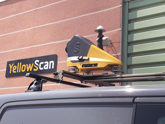
The YellowScan Fly&Drive with the YellowScan Surveyor Ultra mounted on a car
The system consists of a lightweight LiDAR sensor that can be mounted on both UAVs and vehicles, along with software for data processing and analysis. This dual capability allows for efficient topographic mapping, forestry management, and infrastructure inspection. The Fly & Drive system is designed for high accuracy and reliability, delivering precise 3D data in challenging environments. Its versatility makes it ideal for users who need to capture detailed spatial information from aerial and ground perspectives.
Frequently Asked Questions
What is mobile LiDAR scanning?
Mobile LiDAR scanning is a data capture method that combines a 3D laser scanner with a moving platform. The intent is to capture 3D point cloud data continuously while the vehicle is moving.
What is the accuracy of mobile LiDAR?
The accuracy of mobile LiDAR data typically ranges from 1 to 10cm, depending on factors such as the quality of the LiDAR sensors, GPS and IMU integration, and the scanning conditions. Additional factors including speed and data processing techniques also influence data accuracy.
What is mobile GIS mapping?
Mobile GIS mapping refers to mobile data capture for GIS workflows, such as inspection-based workflows. An example is a spatial database of all traffic lights in a city, containing the locations, imagery and metadata of all items (such as the condition of each item). Mobile mapping systems acquire panoramic imagery so GIS analysts can evaluate the condition of all these items over time as new data is acquired.
What is mobile LiDAR used for?
Mobile LiDAR is often the preferred data acquisition method for capturing 3D scenes of cities and road networks. Apart from generating 3D maps and road networks, mobile scanning data may also be used for 3D models of structures, topography, and vegetation. This makes it a great tool for mapping, urban planning, and infrastructure construction.
Resources:
- “Introduction to Pointcloudmetry: Point Clouds from Laser Scanning and Photogrammetry”, by Matthias Lemmens (Whittles Publishing, 2023)
- Webinar: An Inside Look at Mobile LiDAR & Imagery Data Processing
- Navigating the Depths: The Power of Handheld Laser Scanners in Underground Tunnel Mapping
- UK’s Northern to equip trains with LIDAR scanning technology