LiDAR Data Processing: Deliverables and Key Steps

This article covers how LiDAR data is processed. We’ll cover the different steps required to turn raw point cloud data into useful information, and why these are important for end users. We’ll conclude with a brief overview of the functionality of CloudStation, which is YellowScan’s LiDAR data processing software.
What is LiDAR data processing and why is it important?
Laser scanners or LiDAR scanners capture their surroundings in 3D point clouds. These consist of billions of points and their coordinates of their position in space. Laser scanners capture raw point cloud, meaning the points are unfiltered and unstructured. Laser scanners store raw point cloud data as tabular data with the points, their location and different attributes (such as reflectance or RGB values).
YellowScan published a separate article on LiDAR point clouds, explaining how they are collected, visualized, and which data they contain. Also available is an article on how LiDAR scanners collect point clouds. How LiDAR works is covered in yet another article.
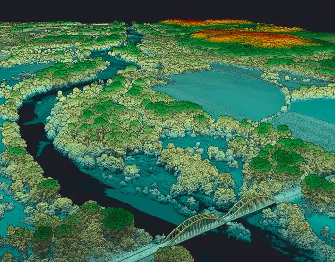
LiDAR data processing software takes the raw point cloud data from LiDAR scanners to generate and visualize 3D point clouds. These resemble the environment as humans would perceive it, with separate objects and surfaces in realistic colors and without incorrect data points (noise). Point cloud processing software produces and exports point cloud data and 3D digital data models. Let’s discuss these outputs in more detail before describing the different data processing steps.
Which deliverables does LiDAR processing software generate?
Raw point clouds provide the basis for many different outputs, including the following 3D data and deliverables:
• DEM (Digital Elevation Model): A DEM is a 3D representation of a terrain’s surface created from LiDAR data. It captures the ground surface without any vegetation or structures.
• DSM (Digital Surface Model): a 3D model of the Earth’s surface, including both the terrain and any objects on the surface.
• Classified Point Cloud: a point cloud containing different classes such as ground, vegetation, buildings, and water.
• Contour lines: usually displayed as lines connecting points of the same height on 2D maps, contour lines represent elevation changes for civil engineering and land development projects.
• Geometric feature: features such as buildings, powerlines and utility poles can be extracted from LiDAR data, to be used for digital twin creation or specific utility applications.
• Cross sections: a cross section shows the elevation profile of a surface in 2D.
With so many different outputs, the market demand for highly-accurate LiDAR data is high. Let’s now have a look at the different tasks performed with LiDAR processing software.

The different steps of LiDAR data processing
Generally, LiDAR data processing covers the following tasks:
• Point cloud filtering
• Point cloud classification
• Point cloud visualization and analysis
• Surface modelling for 3D model creation and data export
Because LiDAR service providers may offer different data processing services, it’s not possible to give an overview of data processing steps that matches every provider’s service offerings. This article only is meant to give an introduction on the topic and will cover only the most common data processing steps.
Another differentiator in distinguishing different data processing steps is the type of LiDAR used to capture point clouds. For example, when point cloud data is captured using a drone or plane, data processing software might be used for post-processing the trajectory or flight path to refine the position and orientation information from that same flight path. Additionally, the relative accuracy of the point cloud may be refined by optimizing how well overlapping flight lines match with each other.
We’ll now cover three data processing steps: point cloud filtering, classification, and analysis.
Point cloud filtering
Point cloud filtering and cleaning is performed to remove erroneous points. There are different reasons for their occurrences in the data, and it’s important to detect and remove them so they won’t affect the accuracy and reliability of the point cloud or 3D model.
There are different types of erroneous points in LiDAR, such as noise , outliers, multipath returns. While erroneous points may be captured in the field as a result of sensor inaccuracies, reflective or transparent surfaces that scatter the laser unpredictably, they also may be the result of misclassification during the data processing.
Data filtering can be done using a variety of methods, such as density-based filtering. This method identifies and removes points from a point cloud based on the local density of points by evaluating how many points exist within a certain neighborhood or area, and removing points that are considered too sparse (low density) or too dense (high density). The benefits including removing noise, redundant data, and improving the clarity of the point cloud.
Point cloud classification
This step involves assigning a class or label to each captured point. This helps to understand what the different points represent. The individual points are identified and categorized according to their soil type, vegetation type, or as buildings, ground, or water. A typical classification used for LiDAR is ground and non-ground points. DSMs for example use ground and non-ground points to distinguish between the ground and other surfaces.

This classification helps create accurate terrain models and identify objects of interest for applications such as robotics. The classification process includes extraction of features, segmentation and clustering of the point cloud based on spatial and geometric similarities, and running different classification algorithms.
Point cloud analysis and visualization
Depending on the application for which the point cloud is meant to be used, different outputs are generated from the point cloud such as contour lines, object volumes, or 3D models. Examples of point cloud data exports include DEMS, DTMs, as well as object structure scans which display smaller objects compared with DEMs and DEMS covering larger areas.
Surface modelling for 3D model creation
This includes converting point clouds into continuous surfaces, which makes for more visually interpretable 3D models. Surface modelling includes creating triangles and polygons between adjacent points. DEMs and DTMs are then created and exported in appropriate data formats.
Additional data processing steps
The preceding overview of different data processing steps is not comprehensive: for example, additional data overlays and checks such as using ground control points can improve the precision and accuracy of the data, so that it meets survey-accuracy requirements. Ground control point data is acquired in the field separately from LiDAR point clouds so that it provides an independent data source to compare the LiDAR data accuracy with.

What is YellowScan CloudStation?
YellowScan CloudStation is an evolutive and user-friendly software for generating point clouds from raw LiDAR data. It also allows for visualizing and inspecting points clouds in-depth. The desktop software product includes four modules:
The strip adjustment module enhances the accuracy of the point cloud with a seamless adjustment of flight lines. The terrain module performs automatic “ground – non-ground” classification of LiDAR points. The colorization module performs point cloud colorization from simultaneous LiDAR and camera acquisitions. The export module outputs point clouds in LAS/LASZ format, and digital model export for DSM and DEM.
Multiple new features have been recently added to CloudStation, including the following:
• Orthophoto generation from LiDAR and camera data.
• Ground Control Point (GCP) visualization: import a GCP and select whether they are tie-points, check-points, or points of interest.
• Online point cloud export: export to a cloud provider from inside of CloudStation.
CloudStation is a core software with different features or modules. YellowScan introduced three different bundles to give clearer options to customers regarding functionality: CloudStation Essential, CloudStation Pro, and CloudStation Ultimate. For more info, have a look at the CloudStation product page.
Frequently Asked Questions
What is LiDAR data processing?
LiDAR processing translates raw point cloud data into accurate and usable information. LiDAR data processing includes multiple steps, such as data filtering and cleaning, point cloud classification, feature extraction, and 3D modelling.
What are the requirements for LiDAR data processing?
The requirements for LiDAR data processing include high-quality point cloud data, with key attributes such as x, y, and z coordinates, intensity, and classification. Additionally, metadata such as flight and sensor information, ground control points and a geographic coordinate system are necessary for improving spatial accuracy. Point density is a metric that expresses the amount of points per square meter: higher point densities allow for more detailed modelling of terrain and objects.
How is LiDAR data collected?
LiDAR data is collected using 3D laser scanners that use laser pulses to measure the distance to a target. Using the speed of light, the time a pulse takes to hit a target and return to the sensor enables a range measurement to a target. Millions of pulses per second enable capturing a scene in 3D. LiDAR data is collected using static and mobile scanners, as well as using drones or airplanes.
What is LiDAR in data annotation?
LiDAR in data annotation involves labeling or tagging objects within that data so that machines can understand and learn from it. LiDAR data is used to train machine learning models for applications including autonomous driving, geospatial analysis, and environmental monitoring.
Why use LiDAR data?
LiDAR data is highly accurate (centimeter-precision). The data is captured rapidly and in an automated way, which is makes it scalable and more cost-effective than manned surveying crews. Compared with photogrammetry, which captures large quantities of 2D imagery to produce a 3D point cloud, LiDAR captures and stores point clouds directly on the scanner and is able to capture data underneath vegetation.


