Drones and LiDAR: A Revolution in Surveying

This article covers how drones are used for surveying. The focus lies on lidar-based surveying using drones. We’ll explain how drones can capture survey-accuracy data, what type of data is captured, what data deliverables are created, and who uses it.
What is drone-based surveying?
Drone-based surveying (or mapping) uses unmanned aerial vehicles (UAVs) to collect spatial data from the air. Instead of using ground crews to measure the dimensions of a particular area of the earth’s surface, drones equipped with 3D laser scanners and cameras can collect spatial data from the air. That data is used to produce a finished map or 3D model.
Why is drone-based surveying popular today?
Drone technology has become more reliable and safe over time. Smaller and lighter payload systems that integrate batteries, digital data storage, camera, and laser scanning technology enable professional drone-based surveys. As a result, drones have redefined the surveying profession and have become an indispensable mapping and surveying tool.
What are the objectives of drone-based surveying?
Before using drone technology and mobile mapping systems, surveying crews would visit a site and carry out one or more of the following tasks:
- Determine the relative position of any objects or points on the earth;
- Determine the distance and angles between various objects;
- Prepare a map or plan to represent an area on a horizontal plane;
- Define control points and boundaries of an area.
Drones are now a popular alternative for terrestrial surveying to capture 3D point clouds. These form the basis for several surveying-grade deliverables that allow for determining distances and angles between objects and the position of objects inside the model.
Which deliverables are created from LiDAR drone surveys?
The deliverables created from 3D point clouds include 3D terrain maps, topographic maps, contour maps, and more:
- 3D terrain maps: maps with a three-dimensional representation, usually of terrain, materialized as a physical artifact.
- Topographic maps: large-scale maps that define and locate natural and manmade features like woodlands, waterways, important buildings, and bridges.
- Contour maps: 2D topographic maps illustrated with imaginary contour lines that connect points having the same elevation;
- DEMs: short for Digital Elevation Models (or “bare earth models”), which are representations of the bare ground topographic surface of the earth excluding trees, buildings, and other surface objects.
- Colored point clouds: combines a (greyscale) 3D point cloud and RGB information from the raster imagery captured with a photogrammetric camera, resulting in a photorealistic 3D point cloud.
What industries are using drone survey data?
Drone surveys are used in surveying, mining, agriculture, urban planning, and construction.
- Surveying: drone surveys enhance traditional surveying methods, offering high precision and detail;
- Mining: mining companies use LiDAR systems to capture geospatial information of the natural surface, the infrastructure of a mine, its planned extension, and to calculate production volumes.
- Agriculture: LiDAR enhances agricultural productivity by providing detailed insights into crop health and field conditions;
- Urban planning: by providing comprehensive and up-to-date information about the urban environment, LiDAR helps city planners allocate resources more efficiently.
- Construction: construction companies and civil engineers use UAV LiDAR solutions in diverse projects to create Digital Terrain Models (DTM), Digital Surface Models (DSM) or Digital Elevation Models (DEM).
Different types of drone surveys
We’ll now cover two main types of drone-based surveys: LiDAR-based and photogrammetry-based drone surveys.
What are LiDAR-based drone mapping and photogrammetry-based drone mapping?
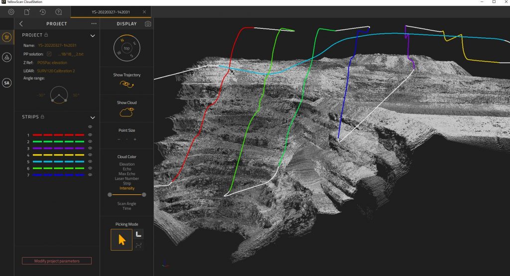
LiDAR-based drone surveying uses 3D laser scanners that capture and store 3D point clouds on the device. These consist of millions of individual points that enable a precise and accurate 3D reconstruction of the scanned area. How LiDAR on drones works is explained in more detail in a separate article.
Photogrammetry-based drone surveys use photogrammetric cameras that capture 2D images. These are then stitched together using special software to produce a single, orthorectified image of the surveying area. This stitching process is a required, intermediate step before producing 3D point clouds and models from the imagery. The differences between photogrammetry and LiDAR are also covered in detail in another article.
What is the role of GNSS receivers in drone surveying projects?
Field surveys use two GNSS receivers to capture accurate measurements. The first is a base station, placed at a known location. It does not move during the survey work. Its function is to receive positioning data from satellites and send it to a second GNSS receiver, held by a surveyor to take point measurements. The stationary base station enhances the accuracy of the data captured with the moving GNSS receiver.
Additional required hardware and software for drone surveys
In the case of a drone survey, the flying drone is equipped with a GNSS receiver, that receives satellite positioning data from a ground-based stationary GNSS receiver, similar to a ground-based survey with a rover and surveyor moving around a site. The difference is that a drone follows a pre-defined route to take measurements and operates autonomously. Specialized drone flight planning software lets surveyors plan their flight in detail before data capture.
Drones are moving platforms carrying a 3D laser scanner and cameras to capture 3D point clouds and imagery during a flight. An IMU (Inertial Measurement Unit) captures the velocity, and orientation of the drone to positioning the scanning system and the data it captures. That information is combined with the scanning data to align all data in a common coordinate system and produce a 3D model of the survey area.
How accurate are drone surveys?
LiDAR technology provides centimeter-level accuracies. For drone surveys, the achieved accuracy depends on the accuracy of the different individual components: the LiDAR, IMU, and GNSS. Perfect accuracy does not exist as every step in the data collection process and creating the outputs potentially adds a small error factor to the result. The achieved accuracy with any drone survey project reflects the value of this error factor as accurately as possible.
When discussing accuracy in drone surveys, a distinction is made between relative and absolute accuracy. These concepts distinguish between precision and accuracy: relative accuracy emphasizes the consistency of measurements relative to each other within the dataset while ensuring that the collected data closely align with true or known coordinates in the real world. In general, survey-grade accuracy implies an absolute accuracy of 10cm or less.
What are the benefits and drawbacks of LiDAR drone surveys?
Drone-surveys with LiDAR are popular for several reasons:
- High-accuracy data: both photogrammetry and LiDAR data captured with drones can meet the high-accuracy standards of the surveying industry;
- Safety: Flying a drone has become safer over time, no longer requiring a human operator to fly the drone when something goes wrong. With drones capturing the data from the air, ground crews no longer have to enter dangerous areas, eliminating risks.
- Accessibility: drones can enter inaccessible sites, such as preserved natural areas. Bathymetric LiDAR surveys are carried out more often with drones, replacing potentially dangerous manned operations.
- 3D data capture: LiDAR captures 3D point clouds directly on the device, whereas photogrammetric cameras need an intermediary step to produce 3D point clouds.
- Forest structure capture: with millions of pulses per second, a LiDAR sensor can pass through small holes between dense forest structures and reach the ground. Having multiple returns from a single laser pulse enables seeing what’s below the canopy.
- Cost savings: drones allow surveying companies to work faster and with fewer personnel. The work of a five-piece crew can be done with a single drone and operator, without compromising on data quality. This enables them to operate faster.
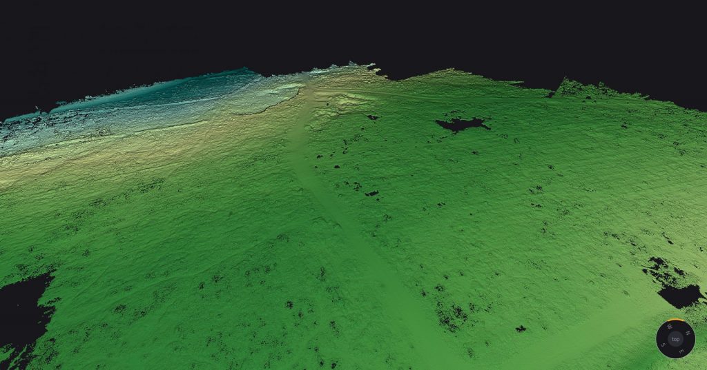
Figure 2. Having multiple returns from a single laser pulse enables seeing what’s below the canopy.
That being said, there are also drawbacks or challenges to using drones for surveying projects:
- Required permits: obtaining permission to fly a drone requires permission from authorities. In the case of BVLOS (Beyond Visual Line of Sight) missions, it may take some time and effort before a project can proceed.
- Extra time and effort to guarantee data high-accuracies: high-accuracy data requires more effort to ensure such accuracies, such as using more ground control points. More effort means higher project costs.
- Limited visibility from the air: built structures such as bridges may obstruct the drone’s view from the air, requiring additional ground-based surveying.
- Intrusive user experience: drone surveys may be experienced as intrusive by others, for example in populated areas such as cities. Here, ground-based surveying may be a better option.
What is the best drone for drone surveying?
The following three drone platform types are used for drone surveying: multirotor, fixed-wing, and single-rotor UAVs.
- Multirotor UAVs include multiple motors that work together to lift the drone vertically.
- Fixed-wing UAVs produce lift power from their wings instead of propellers.
- Single-rotor UAVs feature a single large rotor for lift and a tail rotor that controls direction and stability.
The choice of the best drone type for your mapping project depends on multiple factors, including some of the following:
- The size and shape of the surveying area, which influences the agility for flying, takeoff and landing the drone;
- Maximum available flight time per survey, based on battery power;
- Drone payload, or maximum weight of the drone LiDAR system;
- Flying altitude combined with Field of View (FoV), to find the sweet spot of both productivity and data accuracy;
Fixed-wing drones offer longer flight times than multi-rotor drones and can cover larger areas. A detailed comparison between all three platforms and an overview of all key factors for your next LiDAR drone survey is provided in a separate article.
Selecting the right LiDAR system for your drone can be a daunting task. YellowScan has tested several drone platforms over the last few years, including multirotor UAVs, helicopter UAVs, fixed-wing UAVs, and manned aircraft. For a comprehensive list of UAVs that are compatible with YellowScan LiDAR system, explore YellowScan’s LiDAR platform integrations‘ page.
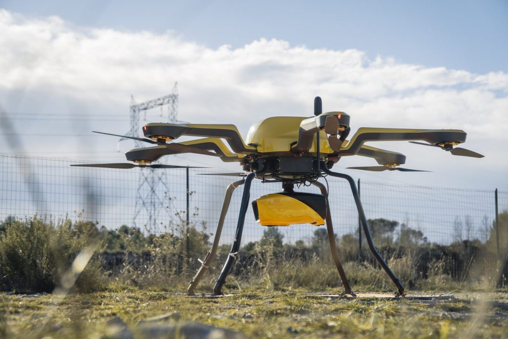
Figure 3. YellowScan Navigator mounted on the Acecore Noa
Frequently Asked Questions
What is drone surveying?
Drone surveying uses unmanned aerial vehicles (UAVs) to collect spatial data from the air with photogrammetric cameras, 3D laser scanners, or both. The data captured with the drone allows for the creation of high-accuracy 3D and 2D models and maps.
How accurate are drone surveys?
Drone surveys provide centimeter-level accuracies. Different techniques help improve data accuracy during and after data capture. These include the use of ground control points, RTK, and PPK. Any drone survey uses two GNSS receivers to guarantee centimeter-level accuracy: one static base station on the ground, that provides satellite positioning data to the drone when capturing the data.
What are the benefits of using drones for surveying?
Drones capture large quantities of high-accuracy data in a short time. That data is consistent in quality and improves safety for operators. Drones are a scalable solution for surveying companies and can be carried out with less personnel than terrestrial surveying projects.
What industries use drone surveys?
Drone surveys are used by the surveying, mining, agriculture, urban planning, and construction industry.
Which drones are best for surveying?
The following three drone platform types are used for drone surveying: multirotor, fixed-wing, and single-rotor UAVs. A detailed comparison between all three platforms is provided in a separate article.