YellowScan and Freefly Systems announce perfect integration of Aerial LiDAR and UAV Technologies,

YellowScan and Freefly Systems announce perfect integration of Aerial LiDAR and UAV Technologies, set to showcase at CUAV Expo in Las Vegas
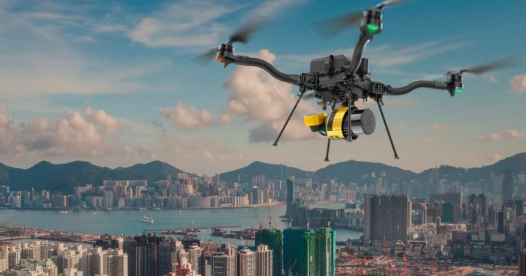
August 23rd, 2024, Montpellier, France and Woodinville, United States – YellowScan, a global leader in aerial LiDAR solutions, is proud to announce its successful integration with Freefly Systems, a renowned innovator in aerial platforms and camera stabilization solutions. This collaboration represents a major step forward in YellowScan’s commitment to offering our customers a diverse range of UAV manufacturers.
By integrating YellowScan’s high-performance LiDAR systems with Freefly’s top-tier unmanned aerial vehicles (UAVs), users can now benefit from an unparalleled combination of accuracy, reliability, and efficiency for aerial surveying and data acquisition.
“We are thrilled to be working alongside Freefly Systems, whose UAV technology complements our LiDAR systems exceptionally well,” said Joseph Dannemiller, Managing Director of YellowScan Inc. “The seamless integration of our systems with Freefly’s drones is a testament to the power of collaboration and innovation. This partnership allows us to provide our customers with an industry-leading, all-in-one aerial LiDAR solution that is reliable, easy to deploy, and highly accurate.”
This partnership highlights the ability of YellowScan’s lightweight and compact LiDAR systems to perfectly match Freefly’s versatile and powerful UAV platforms. The integration ensures that users can achieve maximum efficiency in data collection, covering large areas quickly while maintaining the high precision that YellowScan’s technology is known for.
YellowScan and Freefly’s integrated systems are designed to serve a wide range of industries, including topography, forestry, mining, civil engineering, environmental research, and more. This collaboration empowers professionals to push the boundaries of aerial surveying, delivering faster and more accurate results with greater ease.
“Freefly System operators demand the best performance while keeping workflows quick and easy. YellowScan’s focus on ease of use matched with their robust lidar payloads ensure our mutual customers reliably capture high quality lidar data, every time they fly” said Matt Isenbarger, CRO, Freefly Systems.
Freefly’s innovative UAV technology, combined with YellowScan’s robust LiDAR systems, presents a game-changing solution that enhances aerial surveying, reduces operational costs, and streamlines data acquisition for users worldwide.
Attendees of the CUAV Expo in Las Vegas will have the opportunity to witness the integration. Representatives from YellowScan will be on hand to answer questions and provide deeper insights about this collaboration.
About YellowScan
YellowScan designs, develops, and produces UAV LiDAR solutions for professional applications. Known for their accuracy, robustness, and ease of use, YellowScan’s LiDAR systems are utilized in a range of industries, including forestry, mining, and topographic surveys.
About Freefly:
Freefly Systems is an American corporation that designs, manufactures, and supports several products lines including drones, gimbals, and cameras from their headquarters in Woodinville, Washington.
Resources and additional information
Webpage : https://freeflysystems.com/